

NSD-0104
SS Indus
SL/N/MULA/M/10
- Period
- Colonial - British
- Year sunk
- 1885
- District
- Mullaitivu
- Depth
- 6.00–9.00 m
- Vessel type
- General Cargo Ship, Iron Hull, Passenger, Steam Ship, Bulk Carrier
Overview
There are some mysterious shipwrecks known only through archives and rumours yet to be discovered. The SS Indus is one of the most highly ranked wrecks in this regard. The name of the SS Indus is well known to Sri Lankan and Indian historians and archaeologists. It was widely believed that the ship was transporting a fine collection of sculptures from Bharhut, a well-known ancient Buddhist monastery in India from the 3rd century BCE. The ship was wrecked off Sri Lanka (Ceylon) in 1885 when returning from India via Colombo to London. Over the last century, many researchers have attempted to locate the wreck and its cargo. At the time the SS Indus was wrecked, the renowned British scholar, Sir Alexander Cunningham was the head of the Archaeological Survey of India (ASl). They believed his collection of masterpieces from Bharhut was on aboard, bound for the London Museum. The SS Indus ran aground in 1885 somewhere on the northeast coast of Sri Lanka while she was sailing from Calcutta (Kolkata) to London.
The story of the SS Indus was confined only to interested scholars as it was believed that the ship was wrecked in water so deep that scuba diving equipment could not be used for exploration. It seems no one has made any serious effort to locate the wreck using the actual facts that related to the sinking. The war may also have been a contributing factor in preventing any physical survey of the area. After the MAU expanded their explorations to the north and east coasts from 2012, many wrecks have been recorded and documented. Fortunately, there is a well-preserved collection of 19th-century newspapers in the Colombo National Archives. To locate and identify the history of these wrecks, researchers searched archival records, especially old newspapers. Further, information from local residents was also gleaned and the MAU carried out ‘pre-surveys’ along the targeted coastal areas during which there were opportunities to meet the local fishing communities and obtain useful and reliable information about shipwrecks. As a first step, archival research had been carried out to find evidence and confirm a possible location. Our research revealed that there had previously been great interest among scholars in finding this wreck. However, some misunderstanding about available information had thwarted their efforts; most notably, reports of its location being ‘50 miles north of Trincomalee’ have proven to be misleading. The location ‘50 miles to north’ is a deep-sea area, with depth between 300 and 600 m on Admiralty sea charts, and it is beyond the limits of scuba diving.
Narration by a passenger of the SS Indus – Times of Ceylon, Sunday the 15 September 1885 reads: ‘We left Madras in the Indus at about a quarter to 2.00 p.m. on Saturday afternoon, the 8 September bound for London via Colombo. There were but seven first-class passengers in all, and all went well until the morning of Sunday, the Indus coming to grief in reality but a few hours after we started. I had but just finished my chota hazeri on Sunday morning, and was just entering my cabin when I felt the ship bump, and I was nearly thrown off my feet. Running on deck at once, as indeed did everybody, we found ourselves about four miles from land, which lay to starboard and grating against the bottom heavily…….The ship at this time, so far as we were informed, it must be remembered, had made no water. Towards the afternoon the anchor was let go, and an attempt made to warp her off into deep water, which the boats had found by casting the led………The ship was filling fast and we naturally desired to be out of danger. Our luggage was piled up on the main deck to be washed into the sea. As it eventually proved-but we were not allowed to take it ashore. We took a few wraps with us and rowed ashore with little or no difficulty. There we found a small fishing village called Mullativu where we went to the Resthouse and made ourselves as comfortable as we could...’ (Wreck of the P&O SS Indus, The Times of Ceylon, 15 November 1885: 3).
The archival research confirmed that the ship was wrecked not too far from the land and the lifeboats reached the land within one hour, and the land (village) is known as Mullativu and they stayed at the rest house. Mullaitivu is the main town in Mullativu District, Northern Province of Sri Lanka.
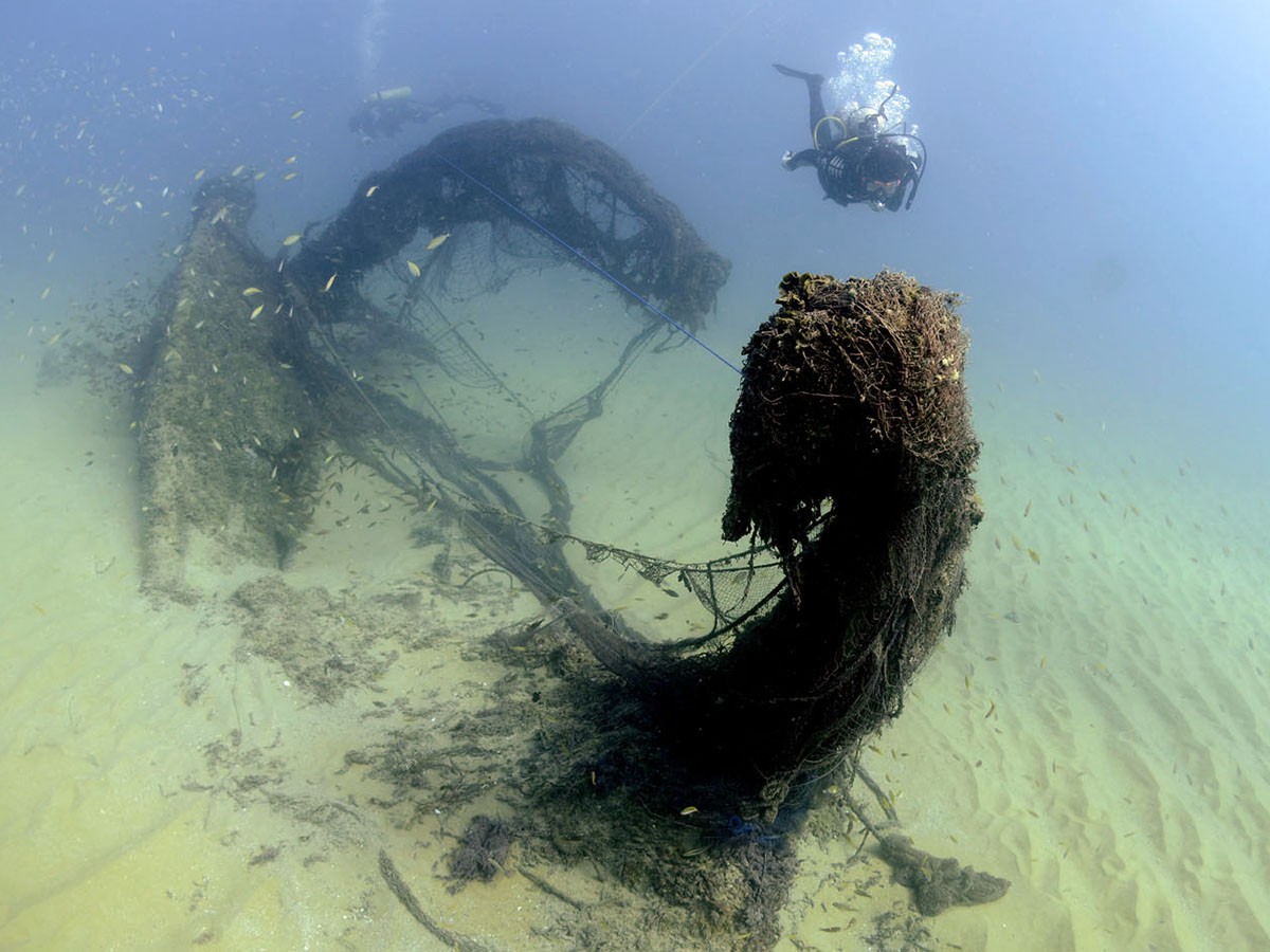
MAU team managed to find a local diver who fishes south of Mullativu near Kokilai lagoon, who had some knowledge of an iron wreck opposite the Mullaitivu lighthouse. Following this lead, an iron wreck on a sandy bottom was located. The new location is 3.5 km north of the previously stated location (on the Admiralty charts) and 6 km northeast of the lighthouse. The half-buried iron wreck at 10 m depth was located but it appeared that most of the superstructure was salvaged some time ago. There were no remains or any identifying marks to indicate that this wreck was the SS Indus. There is no other record of a ship being lost in this area. The evidence on this site indicates that it is unlikely that the wreck had been previously excavated. The location and the distance match the reports from the 1885 newspapers. The area between the bow to mid-ship is fully covered with sand and has concealed the wreck. However, the amidships to the stern is half-buried and appears that around 2 m of the hull is still under sand. Some cargo or other items remaining in the lower deck may well be preserved beneath the sand. To conduct an excavation, it is essential to establish the identity of the wreck, prior to expending valuable resources on an unknown entity. During the years that followed, the MAU has attempted to identify the wreck by completing small scale excavations while recording and measuring the wreck site. In 2014 the site was measured, and a site plan was drawn. The work was complicated due to the entanglement of fishing nets, creating difficulties and danger, and the nets were cleared before measurements commenced.
The ships length and construction details are close to the specifications of the Indus, but there is no other evidence to confirm its identity. No work has been carried out during 2015. During the following year, the team recommenced searching the wreck site by carrying out small scale excavations and clearing and cleaning the surface of the deck floors. During these explorations, some potsherds, metal objects and a tiled floor/deck floor area were found. Part of the deck was covered with terracotta tiles. This area was documented, and some pieces were brought up. Among the metal object, there was a small jar with a symbol of the rising sun which is the symbol of the P&O Company. This was one of the first positive indications that this was indeed the wreck of the SS Indus. With this lead, the fieldwork and excavation work was carried out during 2017 with the intention of finding out the thickness of the sand cover inside the ship between amid-ship and stern. A 2 × 2 sq. m on the port side was selected for excavation. After recording the selected area, excavation was carried out using a water dredger. The excavation continued for nearly two weeks, but the team was unable to reach the bottom of the ship. There were a lot of debris, seashells and concretions, which needed to be removed by hand as they created obstructions inside the suction hose, which needed constant clearing by divers which required them to frequently stop work. Another problem was the high rate of refilling and the team returned each day to find that the excavation trench was half-filled during the night.
Builders : William Denny & Brothers , Yard : Dumbarton , Country : UK
Gross tonnage : 3,462 grt , Length :109.81m (360.4ft) , Breadth :12.31m (40.4ft) , Depth :10.39m (34.1ft) , Draught : 7.467m (24ft 6in)
Power: 2,368 ihp , Propulsion: Single screw , Speed : 13 knots
Passenger capacity : 129 first class, 50 second class , Cargo capacity : [1883] 2,971 cubic metres (104,950 cubic feet)
17.02.1870: Laid down as Timsah. The contract had been purchased for £106,100 from Burns & McIver (Cunard Line). She was a sister to Cunard’s Parthia, and the first P&O ship with a straight stem.
20.02.1871: Launched as Indus.
22.04.1871: Registered.
05.05.1871: Stranded at the mouth of the River Leven.
08.05.1871: Refloated.
10.05.1871: Ran trials and delivered as Indus for The Peninsular and Oriental Steam Navigation Company. Her name is from a great river of the Indian subcontinent rising in Tibet and flowing through what is now Pakistan, reaching the sea south of Karachi, it had previously been used by P&O in 1847.
03.06.1871: Maiden voyage Southampton to Bombay via Suez.
17.03.1874: Ran down and sank the sailing ship Princess Samawathy off Gravesend.
24.11.1874: Collided with the steamer Abbotsford when outward bound of Dover, and put into Southampton for repairs. The other ship was alleged to have turned into Indus’s starboard quarter and was initially found wholly to blame, but this was reversed on appeal.
09.11.1875: Re-registered in Glasgow.
06.1876: Broke down and towed to Singapore. 1878: Fitted with new compound engines by J Howden & Co, Glasgow.
08.11.1885: Stranded on Muliavattu Shoal, 95km (60 miles) north of Trincomalee, Ceylon, when on passage from Calcutta to London with wheat, 780
chests of indigo, tea and 22 passengers, about half travelling on deck..
09.11.1885: Started taking water, slipped off the reef and sank in deep water, together with most of her cargo. The passengers and mails were taken to Trincomalee by the gunboat HMS Ranger, with the P&O steamer Clyde picking up the officers and some of the crew. Captain Breeze’s certificate was suspended for 12 months for not using the lead when in sight of land, and not making allowances for the set of the current. The ship’s chart of the area was reported to be out of date.
Media gallery
·
Location
District: Mullaitivu
Province: Northern
Depth profile
6–9 m
Protection & status
- Access
- None
- Legal status
- None
- Archaeological value
- High
- Physical protection
- None
- Degradation
- Corrosion
- Owner terrain
- Dept of Archaeology
- Owner site
- Department of Archaeology
- Authority
- DOA & MAU-CCF
- Threat
- Corrosion
Vessel chronology
1885
Year sunk
1871 – 1885
Time period estimate
References & publications
- https://www.poheritage.com/Upload/Mimsy/Media/factsheet/93366INDUS-1871pdf.pdf - 2016.02.17
- නන්දදාස එස්.එම් (2013) SS ඉන්ඩස් නෞකාව සොයා යන ගවේෂණ ඇරඹෙයි (පළමු කොටස), දලනිඳු, විද්යුත් පුවත් සරණිය, වෙලුම 05, කාණ්ඩය 03, ජූලි 2013, මුහුදු පුරාවිද්යා ඒකකය, මධ්යම සංස්කෘතික අරමුදල
- නන්දදාස එස්.එම් (2013) ඉන්දියාවේ භාරුත් හි අගනාම කලාකෘති ශ්රී ලංකාවේ උතුරු මුහුදේ : SS ඉන්ඩස් නෞකාව සොයා යන ගවේෂණ ඇරඹෙයි (දෙවන කොටස), දලනිඳු, විද්යුත් පුවත් සරණිය, වෙලුම 06, කාණ්ඩය 01, ජනවාරි 2014, මුහුදු පුරාවිද්යා ඒකකය, මධ්යම සංස්කෘතික අරමුදල
Related shipwrecks
.jpg)
15 Km west Of Colombo
SS Worcestershire
Bamba Wisi Haye Nawa
SL/W/COLO/M/07
- Period
- 1 st World War
- District
- Colombo
- Depth
- 50–60 m
.jpg)
17 Km west of Colombo
SS Perseus
Athnagulpita Nava
SL/W/COLO/M/15
- Period
- 1 st World War
- District
- Colombo
- Depth
- 35–40 m
.JPG)
06 km West of Negombo
Musgrave (1885)?
Negombo Shallow Wreck
SL/W/NEGO/M/25
- Period
- Colonial - British
- District
- Gampaha
- Depth
- 8–11 m
.JPG)
NSD-0039
SS Ava
Irakkandi Wreck
SL/E/IRAK/M/01
- Period
- Colonial - British
- District
- Trincomalee
- Depth
- 6–9 m